


Placemaking is a rural responsibility too
 Print
Print Email
EmailPlacemaking is not just for urban and built environments. It has an important rural component also. Here is one quick and easy way for rural governments to do their part with placemaking.
There has been much discussion about placemaking and its importance as an economic development strategy for the new, or global, economy. But much of the discussion and guidelines focus on urban and built environment. But there is rural placemaking also.
In the new economy the focus is to attract knowledge workers to your region. For the most part knowledge workers want attractive communities with strong amenities, culture, locations with pizazz, which capitalize on their unique characteristics. Knowledge workers provide the skills and talents which new economy industry wants. Those industries will locate in communities that are successful attracting knowledge workers, or those knowledge workers will be the entrepreneurs and innovators that start new businesses.
But building quality place is not just the urban or built environment. It is an entire region. People do not just want a lively downtown. They want variety. So for a region to be economically successful it takes teamwork. The team includes the city or village that has the quality vibrant downtown, the park system that offers a variety of recreation, natural areas, and so on. The nearby residential areas which are safe and walkable. And rural townships which champion their natural, scenic, farm, and rural open space assets. The region needs to have the whole package that appeals to a large cross section of people, knowledge workers.
So how does a rural township do placemaking? It is the same process as any asset-based economic development planning process. Start by listing the assets the community has. Survey and list the following features that exist in your community:
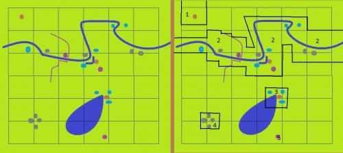
- Areas of cultural and historical significance: archaeological sites, historic sites, historic structures (grey dots on the left side of the accompanying map).
- Areas of aesthetic or scenic significance: scenic overlooks, scenic roads, scenic areas (purple dots [or lines for roads/routes/trails] on the map).
- Areas of natural significance: rare or different geological features, glacial or geological formations, areas of endangered threatened or rare species or species habitat (brown dots on the map).
- Locally unique areas: forest lands; older trees; unique non-forested lands; unique water features waterfalls, springs, kettle or oxbow lakes, wetlands; pristine environments (light blue on the map)
If not already known, sources to work with to build such a list can include the region’s land conservancy, Michigan Department of Natural Resources, Michigan Natural Features Inventory, Michigan State [historic] register list, Natural Resources Conservation Service (your local conservation district), historical societies, national and state parks administration, the United States Forest Service, and tribal governments in the region.
Once the list is done use a map of your township and show the location of each item on the list on the map. The map shown with this article, on the left side of the illustration, shows what that might look like for a typical six by six mile township. Very often these features will cluster together. So when you look at the map the features will be in certain areas rather than spread evenly throughout a community.
The third task is to draw a boundary around those clusters. The boundary should be drawn using natural features. For example on the map on the right side, the boundary along both sides of the river might be approximating the steep banks of the river valley, adjacent roads or similar. The boundaries are “squared-off” so they follow existing public land survey lines or existing property boundary lines.
The result is a township map with a possible five different special and unique areas (right-hand side of the illustration with this article). These areas have unique features which can be considered as groups of assets for rural placemaking. For example, area number two on the map is the corridor associated with a major river. That has potential to be a recreation corridor. Maybe placemaking is creation of hiking trails along both sides of the river. Capitalizing on the scenic road and bridge over the river for fall color tours may be another placemaking project. It also has special features, such as the ox bow lake, wetlands, scenic overlooks and historic sites. There may be reason to create connectivity between the river corridor and the wetland and species habitat on the north end of the inland lake (number three on the map). That might be a bike trail, or wayfinding signs along rural roads, and so on. A potential historic district exists in area number four on the map and old growth forest in area one on the map. Number five is a single scenic spot – maybe a picturesque agricultural lands view which is small in size, but still felt to be very important.
All of these can be attractions, assets, and places which help make an economic region a more complete package. Remember to consider your local government as a part of a bigger area with surrounding townships, counties, and cities. Notice that the river corridor (number two on the map) and old growth forest (number one on the map) extend beyond just the one township and continue into adjoining areas. That means coordination and cooperative work with neighboring governments to create the complete region.
In the master plan these areas are listed, named, and their attributes and values explained (reasons for being included). For example area three on the map might be “Teardrop Lake North Wetland”. It is a special and unique area because it includes a unique geologic features, pristine wetlands, habitat which is essentially undisturbed from pre-European settlement times, an undeveloped part of Teardrop Lake shoreline, and is already in public ownership. These areas are not just for the master plan. These locations are also attractions which can bring tourists to an area. Thus these assets should also be included in a community park and recreation plan too.
These five areas are candidates for special treatment in the community’s zoning ordinance. Each will be different, depending on the reasons for the area and the community’s goals and objectives for the area. For example there may be additional aesthetic protection zoning provisions along the scenic road. The river corridor (area two on the map) may be its own river corridor zoning district. Teardrop Lake North Wetland might also be a special zoning district with very restrictive development standards – or because it is already publically owned that areas protection becomes part of the recreation and parks plan for the community.
Capital improvement program projects might include placemaking projects such as the hiking trail along the river, connecting area one, two, and three with a bike trail; historic interpretation, signs, a new museum in area four. The point is, placemaking is not just for urban built environments. It has an important role in rural areas too. And it is very important in creating an economic region that provides the full range and variety of assets which attract a large cross section of knowledge workers to what is to become a globally competitive region.
Michigan State University Extension has training programs on placemaking and the new economy. These programs are just some of many MSU Extension offerings for local government and community, economic development officials. Contact your local government and public policy Educator to sponsor such training in your county.


